The magnitude 6.8 Al Haouz earthquake in Morocco, which occurred on September 8, drew the attention of researchers from the U.S. Geological Survey’s National Earthquake Information Center (NEIC). Their rapid characterization of the earthquake revealed some unexpected characteristics that shed light on the seismic activity in the region. In this article, we will delve deeper into the findings of the USGS researchers and explore the implications of the earthquake’s unique features.
One of the most surprising discoveries made by the USGS researchers was the depth at which the earthquake ruptured. Traditionally, earthquakes in this region were assumed to occur at shallower depths. However, the Al Haouz earthquake ruptured approximately 25 kilometers deep beneath the surface. This finding challenges the commonly held beliefs about earthquake characteristics in the Atlas Mountains.
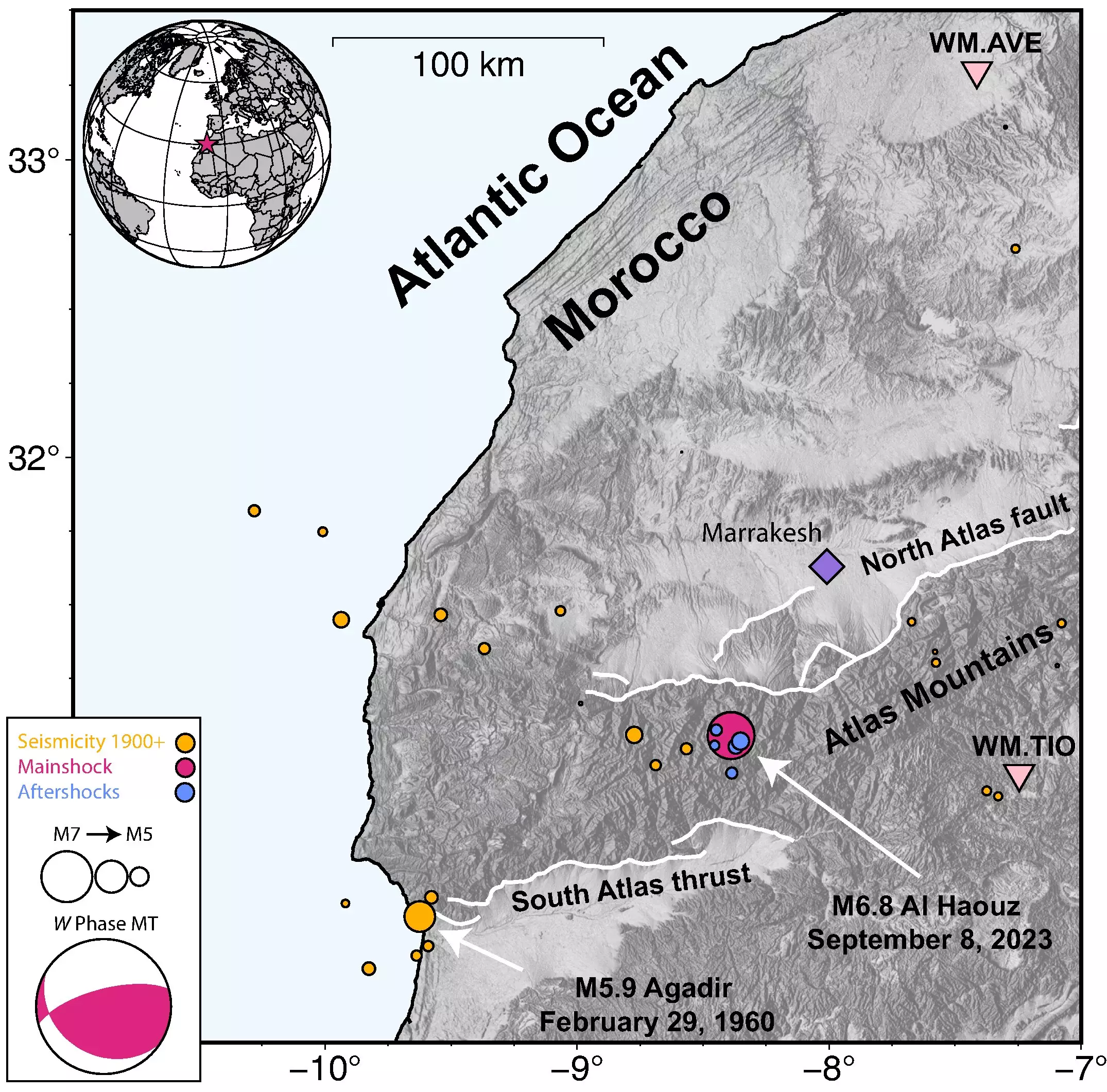
The region where the earthquake took place has very few historically recorded earthquakes. As a result, there is limited information available to establish the “common” characteristics of large earthquakes in the area. Without this baseline knowledge, it becomes challenging to accurately predict seismic hazards. U.S. Geological Survey seismologist William Yeck acknowledges this limitation, stating, “In the region, there’s not a high rate of seismic activity, so we don’t have a great idea of what the ‘common’ characteristics are of large earthquakes in the Atlas Mountains.”
Unconfirmed Faults
The nature of the Al Haouz earthquake posed additional challenges in identifying the faults involved. Since the earthquake rupture did not break the surface, and only a few aftershocks were recorded, it is challenging to confirm which faults were responsible for the seismic activity. This lack of clarity in fault identification hinders efforts to accurately assess future earthquake risks in the region.
The impact of the Al Haouz earthquake was significant, with the Moroccan province being the most affected by the shaking. The city of Marrakesh experienced violent shaking, resulting in nearly 3,000 deaths, 5,500 injuries, and widespread damage to structures in the weeks following the earthquake. The severity of the impact highlights the importance of understanding the characteristics and potential hazards of earthquakes in the Atlas Mountains.
To gain insights into the Al Haouz earthquake, the USGS researchers relied on a combination of teleseismic data and InSAR satellite data. Teleseismic data, collected from seismic stations worldwide, provided crucial information about the earthquake’s depth and other characteristics. InSAR satellite data, on the other hand, captured changes in ground deformation, allowing for a more precise determination of the earthquake’s location on the surface.
The researchers emphasized the importance of leveraging multiple tools and datasets to obtain a comprehensive understanding of earthquakes. By combining waveform modeling and InSAR data, the USGS researchers were able to generate several models of the earthquake source. Waveform modeling provided the best estimate of the seismic centroid and the depth of the rupture, while InSAR data enabled a more precise determination of the earthquake’s location on the surface. The combination of these datasets allowed for a more complete picture of the Al Haouz earthquake.
The source modeling conducted by the USGS researchers revealed that the Al Haouz earthquake occurred in the lower crust, approximately 25 kilometers beneath the western Moroccan High Atlas Mountains. Importantly, the earthquake was classified as a blind rupture, meaning it didn’t reach the surface. This classification adds complexity to understanding the faulting in the region, as surface faults may not accurately represent the faults involved in the seismic activity.
Aftershocks play a crucial role in understanding faulting patterns and identifying the faults that slipped during an earthquake. However, the NEIC database only recorded five aftershocks following the Al Haouz earthquake. This limited number of aftershocks hampers efforts to develop a comprehensive understanding of faulting in the region. Yeck notes, “To understand the faulting in the region, you want to have a good picture of the aftershocks because then you can actually image which faults slipped.”
The unique characteristics of the Al Haouz earthquake in Morocco have provided valuable insights into seismic activity in the Atlas Mountains. The deeper rupture and lack of historical data challenge existing assumptions about earthquake characteristics in the region. The difficulty in confirming fault involvement due to the earthquake’s blind rupture adds complexity to assessing future earthquake risks. It is crucial for researchers and policymakers to continue studying seismic activity in this region to improve hazard assessment and enhance future earthquake preparedness efforts.
Leave a Reply