The Brazilian Amazon, the world’s largest contiguous tropical rainforest, is currently facing a severe crisis due to deforestation and climate change. However, amidst this dire situation, there is a glimmer of hope. A new map has been published, showcasing the above-ground biomass in the region, offering crucial insights into the state and potential future of the rainforest. This map, created through a comprehensive survey conducted using advanced technology and innovative techniques, provides invaluable information for conservation efforts and sustainable forest management. Let us delve deeper into the significance of this groundbreaking study.
The recently published article in Scientific Data highlights the largest survey of tropical forest biomass ever conducted. Led by Jean Ometto, a senior researcher at Brazil’s National Space Research Institute (INPE) and a member of the steering committee for FAPESP’s Research Program on Global Climate Change, the study employed a combination of airborne laser scanning, satellite imagery, and cutting-edge computer processing and machine learning. This multidimensional approach ensured a comprehensive and accurate assessment of the above-ground biomass in the Brazilian Amazon.
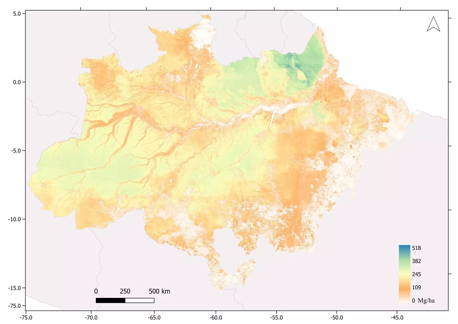
Based on the surveys conducted, the study estimated an average of 174 metric tons of biomass per hectare in the Amazon Rainforest, with a maximum of 518 tons per hectare. These figures provide a clear understanding of the region’s biomass content, enabling researchers to gauge the overall health and vitality of the rainforest. It is important to note that these estimates solely account for above-ground biomass, excluding tree roots. However, considering the significant deforestation that has occurred in recent years, the total biomass in the Amazon is likely to be smaller now.
The main survey utilized airborne laser scanning, also known as LIDAR, to collect data from over 900 transects spanning the entire Amazon. The LIDAR sensor, installed on a low-flying Cessna aircraft, emitted multiple laser pulses per square meter, ensuring a comprehensive scan of the forest. These scans, coupled with data from satellite-based sensors and precipitation measurements, facilitated accurate biomass estimation based on factors such as tree diameter, height, and wood density. This cutting-edge technology played a pivotal role in creating a highly detailed and precise biomass map.
Beyond its current implications, the newly created map opens avenues for further research and analysis. Ometto emphasizes that this is not a static map but rather the foundation for a time series. By conducting surveys in the future, researchers can monitor whether the biomass is increasing or decreasing, offering valuable insights into the impact of deforestation and climate change on the Amazon. With mounting concerns over the rainforest reaching a tipping point and transitioning from a carbon sink to a net emitter of carbon, this continuous monitoring will be crucial in understanding and combating these challenges.
The Amazon biomass map serves as a vital resource for making informed decisions regarding planning, conservation, and sustainable management of the rainforest. In a time when the region’s future hangs precariously in the balance, this map provides policymakers, scientists, and environmentalists with essential information to develop strategies and policies aimed at preserving the Amazon’s biodiversity and mitigating climate change. By leveraging this comprehensive understanding of the biomass distribution, stakeholders can better protect and restore the rainforest.
The surveys conducted during this study have led to several remarkable discoveries. Notably, pre-Columbian geoglyphs were identified, shedding light on the fact that the Amazon was once densely populated. This finding highlights the historical significance of the rainforest and its importance in unraveling the mysteries of ancient civilizations. Additionally, the study confirmed the existence of the tallest tree in the forest, a majestic Dinizia excelsa, with a towering canopy that reaches 88.5 meters above the forest floor. These findings illustrate the depth of knowledge and fascinating insights that can be acquired through advanced scientific research.
The publication of the Brazilian Amazon biomass map marks a significant milestone in our understanding of the world’s largest tropical rainforest. Through pioneering technology and meticulous data analysis, researchers have unveiled crucial insights into the biomass distribution and potential future of the region. This information is vital for effective conservation and sustainable forest management efforts, guiding decisions that will shape the fate of the Amazon in the face of mounting environmental challenges. Furthermore, the study’s revelations about pre-Columbian civilizations and awe-inspiring trees demonstrate the diverse wonders that continue to be discovered within this valuable ecosystem. As we navigate the complexities of climate change and deforestation, this map stands as a beacon of hope, pointing us towards a future where the Amazon thrives and flourishes once again.
Leave a Reply