A recent study by Stanford University has found a way to more accurately measure groundwater levels in the agriculturally rich Central Valley, which is vital for farmers who rely on groundwater to irrigate crops in dry years. The study, published in Geophysical Research Letters, analyzed satellite-based measures of surface changes over time to monitor groundwater levels. However, it also accounts for the effects of the billions of tons of snow piled atop the Sierra Nevada Mountains, which can lead to parts of the Central Valley sinking, muddling groundwater assessments that take sinking as a sign of depleted aquifers.
Impact of Snowpack Loading
Snow and ice in the Sierra during California’s wet season depresses the valley floor, accounting for the majority of the detected elevation change in 60% of the valley. As tens or even hundreds of feet of snowfall pile up in the Sierra, it causes the ground in the valley below to sink by anywhere from a tenth of an inch to an inch. The study shows how heaped-up snow and ice in the Sierra can throw off groundwater assessments tied to elevation changes. The effect of snowpack loading was previously suspected but lacked a way to quantify the effect. The failure to properly account for the effect of snowpack loading could lead groundwater managers whose decisions are increasingly informed by elevation-based monitoring methods to underestimate actual water levels.
Lead study author Seogi Kang, a postdoctoral fellow in geophysics at Stanford, said, “We’ve shown for the first time how to disentangle, decouple, and ultimately isolate the two effects of elevation changes due to groundwater levels and snowpack loading.”
Using Satellite Data to Monitor Groundwater Levels
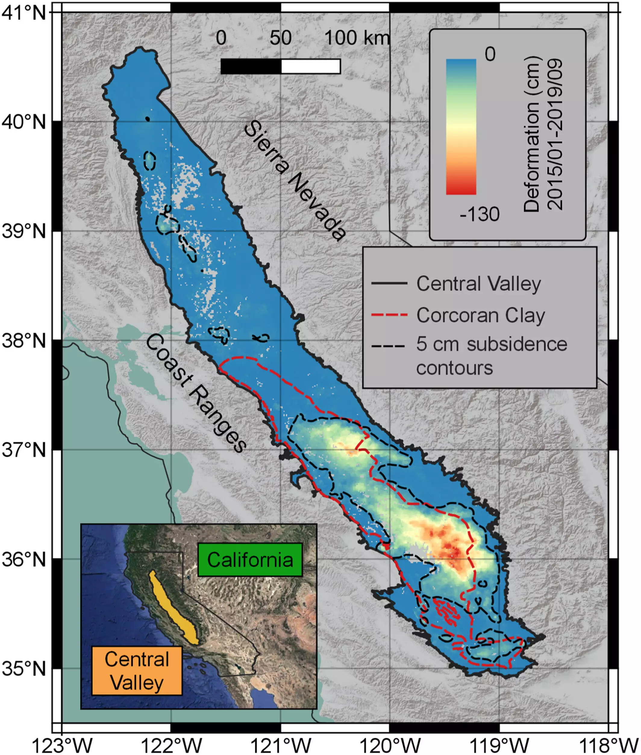
The study used five years of elevation data gathered using a technique known as interferometric synthetic aperture radar (InSAR). The InSAR dataset used for the study spans nearly all 18,000 square miles of the Central Valley, with measurements taken once per week on average between 2015 and 2019. The resolution isn’t perfect but is far better than common groundwater monitoring methods that involve drilling wells sporadically across the vast Central Valley and checking readings a few times per year.
Kang created a statistical machine learning program to sift the immense InSAR data haul into similar clusters based on the time variation in the data. These data were then compared alongside monthly average Sierra Nevada snowpack data for the same time period. “Sorting the data like this allowed us to identify the parts of the Central Valley where elevation changes are dominated by hydrological loading—what we call the snowpack effect—and which parts are dominated by the groundwater system,” said Kang.
The study offers groundwater managers a new way of using satellite data to accurately monitor the volume of stored groundwater in the Central Valley. With improved understanding of the hydrogeophysics at play in the region, the researchers hope their approach can support and inform groundwater management decisions, from where and when to cap pumping to how best to allocate new water delivery infrastructure. “So much of the food we eat and enjoy comes from the Central Valley and other places that face significant water supply challenges,” said Kang. “With improved understanding of the hydrogeophysics at play here, we can help ensure the Central Valley’s agricultural productivity remains sustainable.”
Leave a Reply