The mighty force of nature known as Hurricane Lee is exceeding all expectations as it transforms into a fearsome storm, rapidly intensifying as it courses through the vast expanse of the Atlantic Ocean. Forecasters have been closely monitoring its progression, and the latest updates are nothing short of awe-inspiring. With the hurricane’s maximum winds predicted to exceed a staggering 160 mph by the upcoming weekend, the world watches with bated breath.
As of the most recent advisory from the National Hurricane Center, Hurricane Lee boasts maximum sustained winds of 105 mph, positioning itself over open waters. The storm’s trajectory, following a west-northwest path, indicates a likely course that will pass north of the Leeward Islands and Puerto Rico. This prediction places it on a collision course with the highest echelons of hurricane classifications, with experts expecting it to become a major hurricane on Thursday.
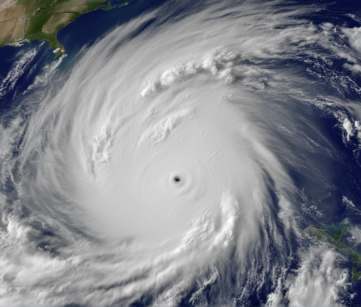
The distinction of a major hurricane, denoted by Category 3 status and above, carries with it the implication of sustained winds roaring at a minimum of 111 mph. Remarkably, Hurricane Lee is expected to achieve this classification on the very same day that it develops a well-defined eye, a key indicator of a hurricane’s strength and organization.
The National Hurricane Center has consistently sounded the alarm, warning that Hurricane Lee has the potential to undergo extraordinary intensification at an astonishing pace, surpassing the rates that are typically observed with model forecasts. This dire forecast has raised a pressing question: just how powerful will Hurricane Lee become, and how rapidly will it reach that point?
The pivotal threshold to monitor is whether Lee’s sustained winds will indeed surpass 160 mph, as anticipated. Surpassing this critical benchmark would catapult Hurricane Lee into the ominous category of a Category 5 storm, a classification reserved for the most ferocious and destructive hurricanes.
The current trajectory forecasted by the Hurricane Center indicates that Lee will continue its north-northwest movement, ultimately positioning itself well north of Puerto Rico by Tuesday morning. This trajectory offers some relief in the sense that the storm currently poses no immediate threat to any landmass. However, it is crucial for residents and authorities to remain vigilant and closely monitor the evolving situation.
It is worth noting that, despite the early indicators, forecasting the exact path and behaviour of hurricanes remains a complex endeavour. Meteorological models offer valuable insights, but they are not infallible. A vivid example of this unpredictability is Hurricane Irma, which in 2017 was anticipated to follow a similar path, but instead delivered a devastating blow to Florida’s Gulf coast. Therefore, while projections are useful, an element of uncertainty always looms in the world of hurricane tracking.
Even if Hurricane Lee avoids direct landfall, meteorologists emphasize the potential for secondary effects. Lee is expected to generate powerful swells, which are predicted to reach portions of the Lesser Antilles on Friday, followed by the British and U.S. Virgin Islands and Puerto Rico over the weekend. These swells carry the ominous potential for life-threatening surf and rip current conditions, underscoring the broader impact of such powerful storms.
The intensification of Hurricane Lee can be attributed to the unusually warm waters it is traversing. These waters, with temperatures hovering around 86 degrees Fahrenheit east of the Lesser Antilles, are typically encountered in the Gulf of Mexico rather than the Atlantic Ocean. Such warmth provides the energy and moisture necessary for hurricanes to intensify rapidly, making Lee’s transformation into a formidable force all the more remarkable.
Hurricane Lee’s emergence marks the 13th named storm in what has proven to be an above-average Atlantic hurricane season. The prolificity of storms this year is noteworthy, as it rivals only a select few years on record. Phil Klotzbach, a renowned hurricane researcher, points out that by September 5th, only four other years—2005, 2011, 2012, and 2020—have witnessed the development of 13 or more Atlantic named storms. This statistic underscores the unusual nature of the current hurricane season.
Hurricane Lee is proving to be a potent force of nature that demands our unwavering attention. Its rapid intensification and unpredictable trajectory highlight the unpredictability of hurricanes and the need for constant vigilance in the face of such natural disasters. While the storm’s current path suggests it may spare some heavily populated areas, the potential for secondary impacts, such as life-threatening swells, should not be underestimated. As Hurricane Lee continues its journey through the Atlantic, we are reminded of the awesome power of nature and the importance of preparedness and resilience in the face of such formidable forces.
Leave a Reply