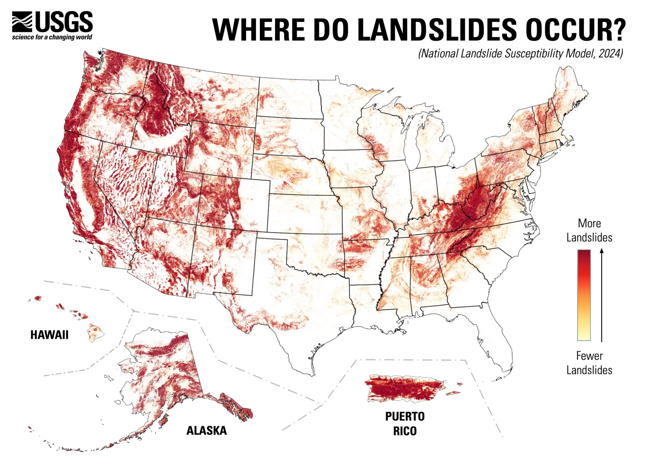
The U.S. Geological Survey (USGS) has unveiled its groundbreaking nationwide map detailing landslide susceptibility, revealing that nearly 44% of the United States faces potential landslide activity. This innovative tool presents a granular, county-by-county analysis of landslide risk, offering essential insights into regions prone to these geologic hazards while identifying areas where the threat is minimal. The information provided will be invaluable for urban planners, engineers, and policymakers as they endeavor to minimize risk and enhance land-use strategies.
The newly released landslide map serves a dual purpose: it aids in risk reduction and informs land-use planning. By pinpointing vulnerable zones, this resource will help stakeholders prioritize actions to bolster community resilience against landslides. Ben Mirus, a research geologist at USGS, emphasizes the importance of this tool, stating, “We are excited that it is now publicly available to help everyone be more prepared.” The map promotes a proactive approach to hazard management, encouraging a nation-wide effort toward becoming more hazard-ready.
Historically, detailed landslide assessments were restricted to select high-risk regions of the U.S., leaving vast areas under-researched. This new map expands the understanding of landslide potential across the country, thus bridging the knowledge gap for many locales where risk factors were previously ambiguous. The collaborative efforts of the USGS team, which involved analyzing nearly one million previous landslide incidents alongside high-resolution national elevation data, represent a significant advancement in geospatial analysis.
The creation of this comprehensive landslide susceptibility model involved sophisticated technology and extensive data analysis. Leveraging information from the USGS 3D Elevation Program, researchers have generated a more precise and detailed depiction of landslide susceptibility than any pre-existing continental or global maps could provide. This emphasis on high-resolution data ensures that potential landslide locations are accurately identified, empowering communities to better prepare for and respond to these natural hazards.
Additionally, the new map offers invaluable information for future research initiatives aimed at improving landslide data collection and mitigation strategies. It highlights territories where further mapping is essential, enabling researchers and practitioners to focus their resources effectively. As communities delve deeper into the factors contributing to landslide risk, they will be better equipped to implement preventative measures and develop adaptive strategies tailored to their specific environmental contexts.
The USGS’s national landslide susceptibility map represents a significant leap forward in our understanding of geologic hazards across the United States. By making this data publicly available, the USGS empowers communities to take charge of their safety and preparedness, fostering a culture of awareness and proactive disaster management. As more individuals and organizations utilize this resource, the likelihood of effective risk mitigation and disaster readiness can greatly improve, ultimately saving lives and protecting property.


Leave a Reply