
Plate tectonics play a crucial role in shaping the Earth’s continental configurations. The lithosphere, which consists of the oceanic and continental crusts and upper mantle, is constantly in motion due to convection processes happening in the softer asthenospheric mantle below. This movement leads to various geological phenomena such as earthquakes, volcanic eruptions, and the formation of mountains, especially at the boundaries of these tectonic plates.
One of the notable plate boundaries on Earth is located between Canada and Greenland, forming the Davis Strait seaway that connects the Labrador Sea and Baffin Bay. Dating back to around 33-61 million years ago during the Paleogene period, this region holds a unique feature – a thicker than normal fragment of continental crust in the ocean, ranging from 19-24 km. This anomaly is now recognized as the Davis Strait proto-microcontinent, which has caught the attention of researchers.
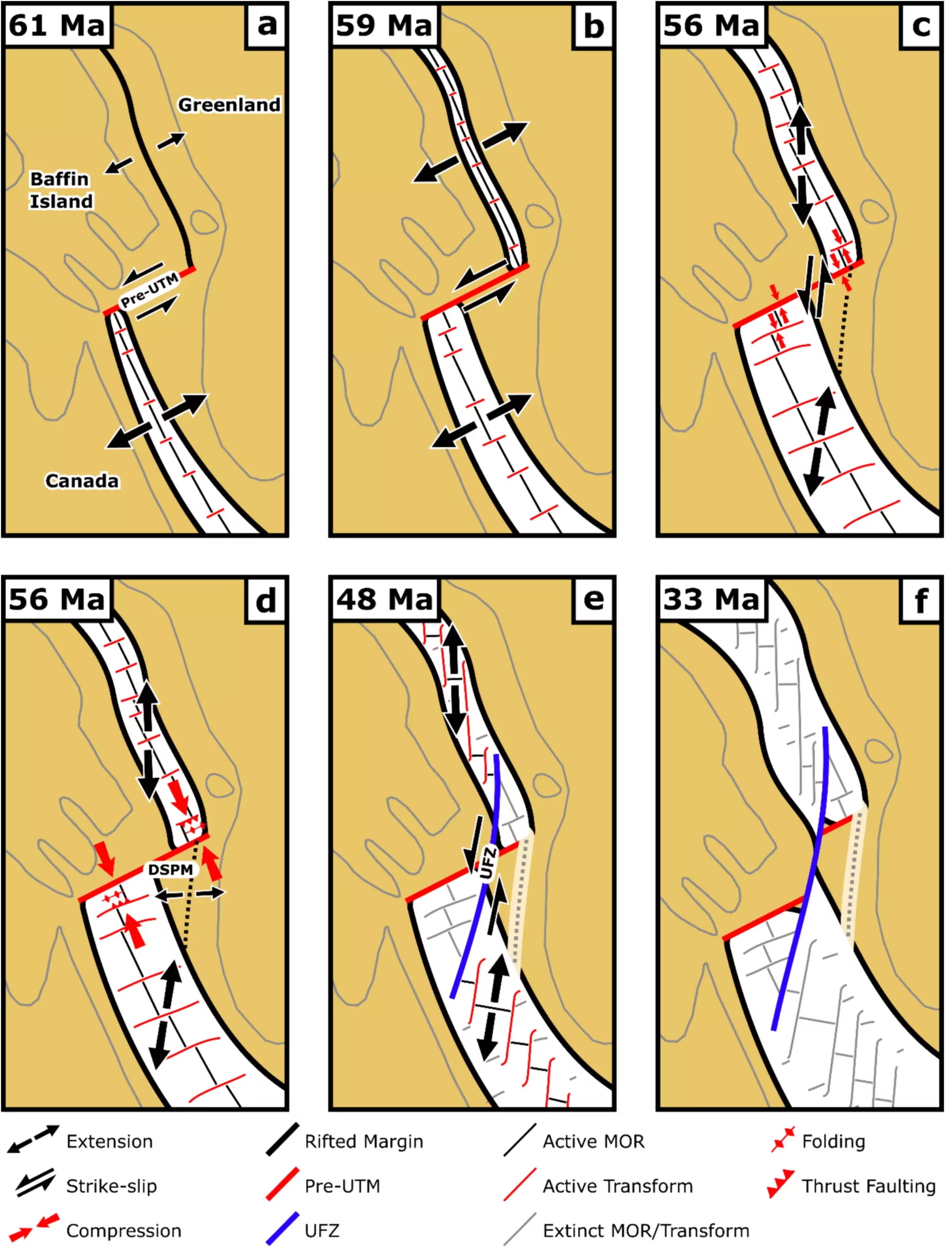
Doctoral researcher Luke Longley, Dr. Jordan Phethean, and Dr. Christian Schiffer have conducted a study published in Gondwana Research, focusing on the mechanism and formation of the Davis Strait proto-microcontinent. Their research involved reconstructing the plate tectonic movements over approximately 30 million years that led to the creation of this geological anomaly. They defined proto-microcontinents as regions with thick continental lithosphere separated from major continents by thinner continental lithosphere.
Dr. Phethean emphasizes the importance of studying microcontinent formation and their relevance to present-day geological processes. The Labrador Sea and Baffin Bay provide an ideal natural laboratory for investigating microcontinent formation due to well-defined changes in plate motion and relatively limited external complications. Understanding how microcontinents form can help predict future geological evolutions, making this research critical for the scientific community.
The research team used gravity and seismic reflection data to map fault orientations, ages, and the process of rifting between Canada and Greenland. They identified the initial rifting starting around 118 million years ago during the Lower Cretaceous period, followed by seafloor spreading at approximately 61 million years ago in the Labrador Sea and Baffin Bay. The period between 49-58 million years ago was crucial for the formation of the Davis Strait proto-microcontinent, with changes in the orientation of seafloor spreading leading to its separation.
The findings of this research have broader implications beyond the Davis Strait region. By studying microcontinent formation in detail, scientists can gain insights into the calving process of continental crust in other parts of the world. This includes microcontinents like the Jan Mayen microcontinent northeast of Iceland, East Tasman Rise southeast of Tasmania, and the Gulden Draak Knoll offshore western Australia. Understanding these geological phenomena can provide valuable knowledge about Earth’s dynamic processes.
Overall, the research on the Davis Strait proto-microcontinent sheds light on the intricate interplay of plate tectonics, continental configurations, and the formation of geological anomalies. By unraveling the past movements and processes that led to the creation of this microcontinent, scientists can better comprehend the complex nature of Earth’s tectonic activities and their implications for the future.
In the realm of software development, the ability to swiftly and accurately address bugs is…
The realm of quantum computing and communication is not just an abstract dream anymore; it…
In a remarkable leap for the field of material science, a collaborative research initiative has…
Throughout Earth's vast history, our planet has endured five major mass extinction events that reshaped…
Rainfall is a vital element of our planet’s hydrological cycle, yet many aspects of its…
On a night when the universe aligns, a mesmerizing phenomenon awaits: the appearance of the…
This website uses cookies.